PD Dr. Bernhard Schuberth
Wissenschaftler und Privatdozent
LMU

I am a geophysicist specializing in mantle dynamics, computational seismology, and the structure of Earth’s deep interior. I hold a PhD in Geophysics from LMU Munich and have held positions at LMU, the Géoazur of CNRS & the Université de Nice funded through a European Marie-Curie fellowship. Currently, I am Head of Seismological Geodynamics at LMU Munich and a principal investigator in several German Science Foundation (DFG) projects, including the DFG SPP 2404 “DeepDyn” priority program. My work combines high-performance computing, interdisciplinary physics, and innovative model–data integration to advance our understanding of Earth’s interior structure and long-term evolution. An important part of my work is to communicate complex geoscience through advanced 3-D immersive visualization and outreach.
CV
Since 2012 Senior Scientist, Head of Seismological Geodynamics, LMU Munich, Germany
2010 – 2012 Marie-Curie Fellow, Seismology Section, UMR GéoAzur, CNRS &Université de Nice-Sophia Antipolis, France
2009 – 2010 Post-Doc, Geodynamics Group, LMU Munich, Germany
2004 – 2009 PhD student in computational seismology and geodynamics within the International Graduate College THESIS of the Elite-Netzwerk Bayern, LMU Munich
2004 Research Assistant, Geophysics Section, LMU Munich
In my research, I investigate Earth’s deep interior by linking mantle dynamics with seismic observations in an integrated way by bridging geodynamics, mineral physics, computational seismology and high-performance computing. The goal is to evaluate competing hypotheses about mantle evolution, deep-Earth heterogeneity, and core–mantle boundary processes. To this end, we run high-resolution numerical simulations of 3-D mantle flow in my group and convert these model predictions into synthetic seismic data—such as full waveform seismograms and normal-mode spectra—to test whether geodynamic scenarios are consistent with real Earth observations. I also advance uncertainty-aware “closed-loop” methods that connect geodynamic modelling and seismic tomography.

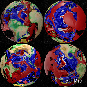
3-D thermal mantle structure at 60 million years ago predicted from a high-resolution mantle circulation model (Iso-surfaces at -600 K (blue) and +400 K (red)). | © M. Wiedemann, Bernhard Schuberth
This research focuses on developing and applying numerical methods to model mantle convection—the slow, viscous deformation of solid rock by creep mechanisms that governs Earth’s long-term geodynamic evolution. Constraining its temporal behaviour and interactions with diverse geophysical and geological processes remains a major challenge. Time-dependent mantle flow models are essential for addressing long-standing questions related to plate-tectonic dynamics, lithospheric stress patterns, global sea-level variations, and core–mantle interactions. By solving the conservation equations of mass, momentum, and energy for a compressible material in a three-dimensional spherical shell, mantle convection models (MCMs) yield self-consistent predictions of density structure and convective forcing. To create such complex models at Earth-like convective vigour, high-performance supercomputing infrastructures are required. Observational constraints, particularly surface plate velocities from global tectonic reconstructions, are assimilated to reproduce realistic locations and realistic morphologies of subducting slabs. The resulting flow fields produce characteristic patterns of mantle heterogeneity that reflect the model’s underlying assumptions and can be evaluated through secondary predictions such as seismic travel times, anisotropy, geoid variations, and true polar wander rates.
Papanagnou, I., Schuberth, B.S.A. and Ch. Thomas, Geodynamic predictions of seismic structure and discontinuity topography of the mantle transition zone, Geophys. J. Int., doi:10.1093/gji/ggac478, (2022).
Nerlich, R., Colli, L., Ghelichkhan, S., Schuberth, B. and H.-P. Bunge, Constraining central Neo-Tethys Ocean reconstructions with mantle convection models, Geophys. Res. Lett., 43, 9595-9603, doi:10.1002/2016GL070524, (2016).
![Snapshots of the three-dimensional wavefield computed in a geodynamic model. The wavefield is depicted by green and magenta colours together with the shear wave velocity variations in the model, for which vertical cross-sections and iso-surfaces are shown on a blue to brownish colour scale [Schuberth et al. 2012]. | © Bernhard Schuberth Snapshots of the three-dimensional wavefield computed in a geodynamic model. The wavefield is depicted by green and magenta colours together with the shear wave velocity variations in the model, for which vertical cross-sections and iso-surfaces are shown on a blue to brownish colour scale [Schuberth et al. 2012].](https://cms-cdn.lmu.de/media/20-geowissenschaften/department-geoumwelt-department/photos/forschung/wavefieldgeodynamicmodel_bernhardschuberth_1_1_format_s.png)
Snapshots of the three-dimensional wavefield computed in a geodynamic model. The wavefield is depicted by green and magenta colours together with the shear wave velocity variations in the model, for which vertical cross-sections and iso-surfaces are shown on a blue to brownish colour scale [Schuberth et al. 2012]. | © Bernhard Schuberth
A central theme in my research is virtual seismology to connect geodynamic models with observable seismic data: We turn the results of MCMs into theoretically predicted seismic signals (e.g., body wave traveltimes, long-period normal modes, and full waveform seismograms) by transforming the temperature field into 3-D seismic velocity models using mineral-physics relations. For these hypothetical mantle structures, we then compute synthetic wavefields, normal mode spectra, and other seismic observables using a variety of tools of varying degree of sophistication ranging from ray-tracing and full-coupling normal mode calculations to full 3-D global wave propagation simulations using the spectral element method. Virtual seismology serves two purposes: it is used to evaluate whether a specific geodynamic model realisation is compatible with observations, and it helps identify which mantle features—such as deep thermal anomalies or transition-zone heterogeneities—are actually resolvable with today’s seismic networks and processing methods. By creating and analyzing these synthetic datasets, we effectively turn Earth’s mantle into an “observable laboratory,” enabling controlled experiments that are impossible with real-Earth measurements alone.
Schuberth, B.S.A. and T. Bigalke, From Mantle Convection to Seismic Observations: Quantifying the Uncertainties Related to Anelasticity, in Mantle Convection and Surface Expressions, Eds. Marquardt, H., Ballmer, M., Cottaar S. and J. Konter, pp.97–120, AGU Geophysical Monograph Series Vol. 263, John Wiley & Sons Inc., Hoboken, NJ, USA, doi:10.1002/9781119528609.ch4, (2021).

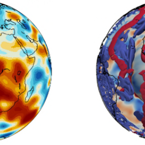
Scale discrepancy between tomographic (left) and geodynamic model (right). | © Roman Freissler
For reconstructing mantle flow back in geologic time, geodynamic inversions require input from seismology in the form of tomographic images. Yet tomographic models typically have far lower resolution than the detailed structures predicted by mantle circulation models. To make mantle flow reconstructions robust, we need a practical way to describe tomographic uncertainty and to understand how limited resolution affects downstream predictions—especially surface dynamic topography. We run a synthetic experiment to demonstrate the difficulties of quantitatively combining tomographic and geodynamic models. Using the Subtractive Optimally Localised Averages (SOLA) method—a linear tomographic framework—and a mantle circulation model as a reference, we explore how resolution limits affect the seismically imaged structure. Based on these tests, we outline a potential workflow for adjoint mantle-flow reconstructions that makes full use of the SOLA method. We further propose assessing SOLA-derived realisations for adjoint geodynamic experiments in the context of closed-loop experiments that quantify how tomographic resolution and uncertainty propagate into mantle-flow reconstructions.
Robl, G., B.S.A. Schuberth Papanagnou, I. and C. Thomas, From seismic models to mantle temperatures: Uncertainties related to mineralogical complexities and limited tomographic resolution, Geophys. J. Int., 241(3), 2003–2027, doi:10.1093/gji/ggaf141 (2025).
Freissler R., B.S.A. Schuberth and C. Zaroli, A concept for the global assessment of tomographic resolution and uncertainty, Geophys. J. Int., 238(2), 992--1012, doi:10.1093/gji/ggae178 (2024).
Freissler R., C. Zaroli, S. Lambotte and B.S.A. Schuberth, Tomographic filtering via the generalized inverse: A way to account for seismic data uncertainty, Geophys. J. Int., 223, 254–269, doi:10.1093/gji/ggaa231 (2020).