Mapping Munich's Hot Spots
25 Jun 2025
The city's garbage trucks are not only collecting waste, but also detailed meteorological data.
25 Jun 2025
The city's garbage trucks are not only collecting waste, but also detailed meteorological data.

© Simon Schnitzler
Summer has arrived in Munich with full force – and while we’re all feeling the heat at 30°C, it’s clear that some parts of the city warm up much more than others. In those areas, more greenery, fountains, or other well-planned climate adaptation measures could make a real difference.
To locate these dangerous hotspots, the city has some rather extraordinary helpers: Garbage trucks are not only collecting waste here in Munich – but from now on also important real-time meteorological data! From the sweltering Dachauer Straße to the cooler Olympiapark, up to 5 trucks map out where dangerous heat islands form in the area.
That idea now grew into a full-scale collaboration between our research group, the InnovationLab Munich, the Abfallwirtschaftsbetrieb Munich (AWM) and most recently also the City of Munich’s Department for Climate and Environment (RKU) where we’ve transformed waste collection trucks into mobile climate sensors. The InnovationLab built the sensors, the AWM provided the sensor mounting platforms – and most importantly: the trucks - we evaluate the data, and the RKU hopefully makes use of the data and to inform sustainable policies and measures.
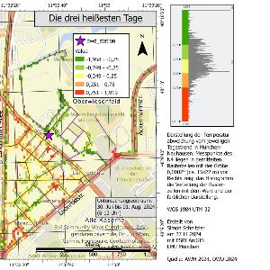
But there’s a catch: As garbage trucks operate across several hours each day, their data varies depending on time of day. Early morning readings are much cooler than those collected later on. Our student Simon Schnitzler tackled this issue in his Bachelor’s thesis by developing a method to normalize the data – and thus laying the groundwork for any analysis. His analysis of three hot days last summer (30.07 to 01.08.) shows, that heat islands have formed especially along Leonrod, Dachauer, and Triva street, while areas around Olympiapark are overall cooler.
The result is an extremely valuable data base that the city can draw on to improve its heat management in the upcoming urban climate analysis. So far, meteorologic data for the city is inferred from fixed monitoring stations and spatial models. But the garbage truck measuring method now offers dynamic measurement in front of your home. Combining our new dynamic measurements with the data from the fixed stations can now yield more targeted measures against heat islands in the city.
And action is urgently needed: According to a recent study by Deutsche Umwelthilfe (Environmental Action Germany), nearly one in three citizens in Munich is affected by heat*. In 2023 and 2024 alone, over 6,000 people in Germany died due to heat, according to the Robert Koch Institute. Climate change is driving more extreme heat days and nights, especially in dense urban areas that trap heat during the day and release it only slowly at night. The difference in temperature between city centres and suburbs can reach up to 10°C.
The data collected from these mobile sensors can hopefully contribute to plan smarter, more equitable interventions – especially benefitting vulnerable groups such as children, elderly people, and those with chronic illnesses: more greenery, ventilation corridors, and cooling spots near sensitive infrastructure.
If you're in Munich and looking to escape the heat, check out this interactive map of cooler places
*The Hitzebetroffenheitsindex [heat affectedness index] is calculated by drawing on surface temperature, sealing, and greenery volume. More info (in German)